Recent searches
Search options

Administered by:

#josm


@dasgrueneblatt Locally, you can easily display #OsmAnd favorites by just open it in #JOSM, but it does not looks very nice. For local customization, it is quite easy to enable labels with just a few clicks in #QGIS. Or (esp. if you want to publish the map) you can use service like https://umap.openstreetmap.de (you also need to enable labels either as always-on or on-popup in GPX layer)

I'm nearing the completion of mapping the basic road surface types for the whole Eastern Cape province of South Africa in #OpenStreetMap. Many months using the new 25cm ZA aerial imagery to help me identify the surface. #JOSM "colourful" setting to the max helps a lot. 98% done. 

Ça vaut ce que ça vaut mais je trouve pratique de faire un méchant [Ctrl] + [A] pour sélectionner tous les objets sur la sélection avec fond vue aérienne d' #osm dans #josm
Ainsi je vois clairement ce qu'il manque en bâtiments, piscines, ...
Bon printemps !
#openstreetmap #PlusBelleLaCarte #carte

 HackW/E@LinuxHotel
 The pTerry #JOSM plugin adds `GNU Terry Pratchett` to the overhead in the #OpenStreetmap “clacks” (changeset tags).
Vous connaissiez https://Framacarte.org ?
C'est une instance du logiciel libre #uMap, une manière facile d'utiliser les fonds de carte d' #OpenStreetMap pour vos besoins perso :
- planifier un roadtrip de vacances
- réaliser et tenir à jour un plan bathymétrique : http://www.port-premier.fr/pages/carte.html
- rassembler les points de vente de la lessive à la cendre Héron Cendré : https://heroncendre.com/#_o%C3%B9_trouver_la_lessive_h%C3%A9ron_cendr%C3%A9
- visualiser le parcours d'une outarde canepetière tant qu'il n'y a pas de bassine là où elle niche en France : https://gebull.org/2022/comment-gebull-a-contribue-a-une-etude-scientifique/ (bon, en vrai on a utilisé #JOSM là, mais vous, vous auriez pu utiliser #Framacarte / uMap).
We've all seen the issues with using #Bing aerial imagery being sometimes unusable in #JOSM. 
The OSMF's EWG has been in touch with #Microsoft 2 weeks ago, and are waiting for a response. 

 So please stand by!

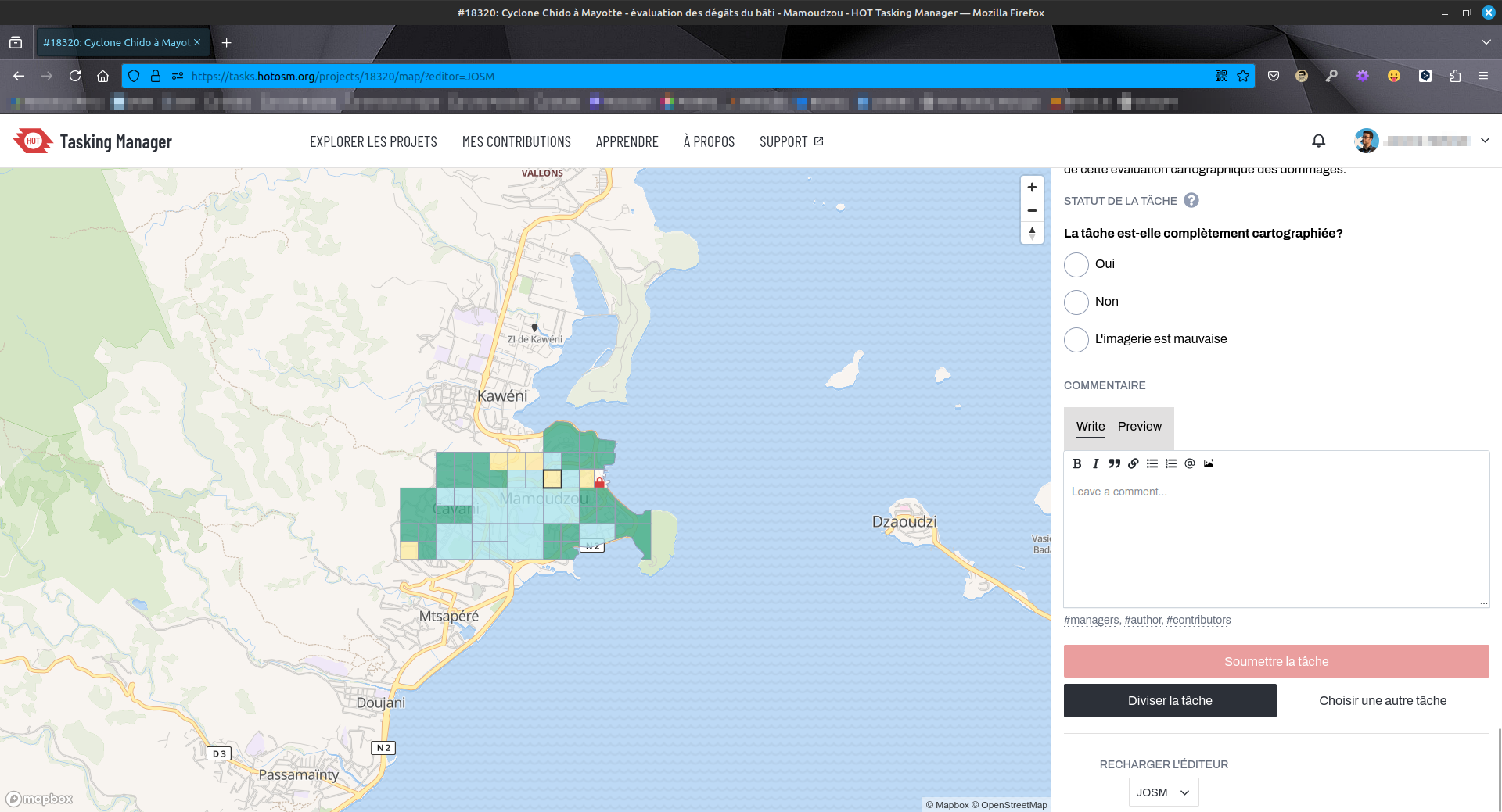
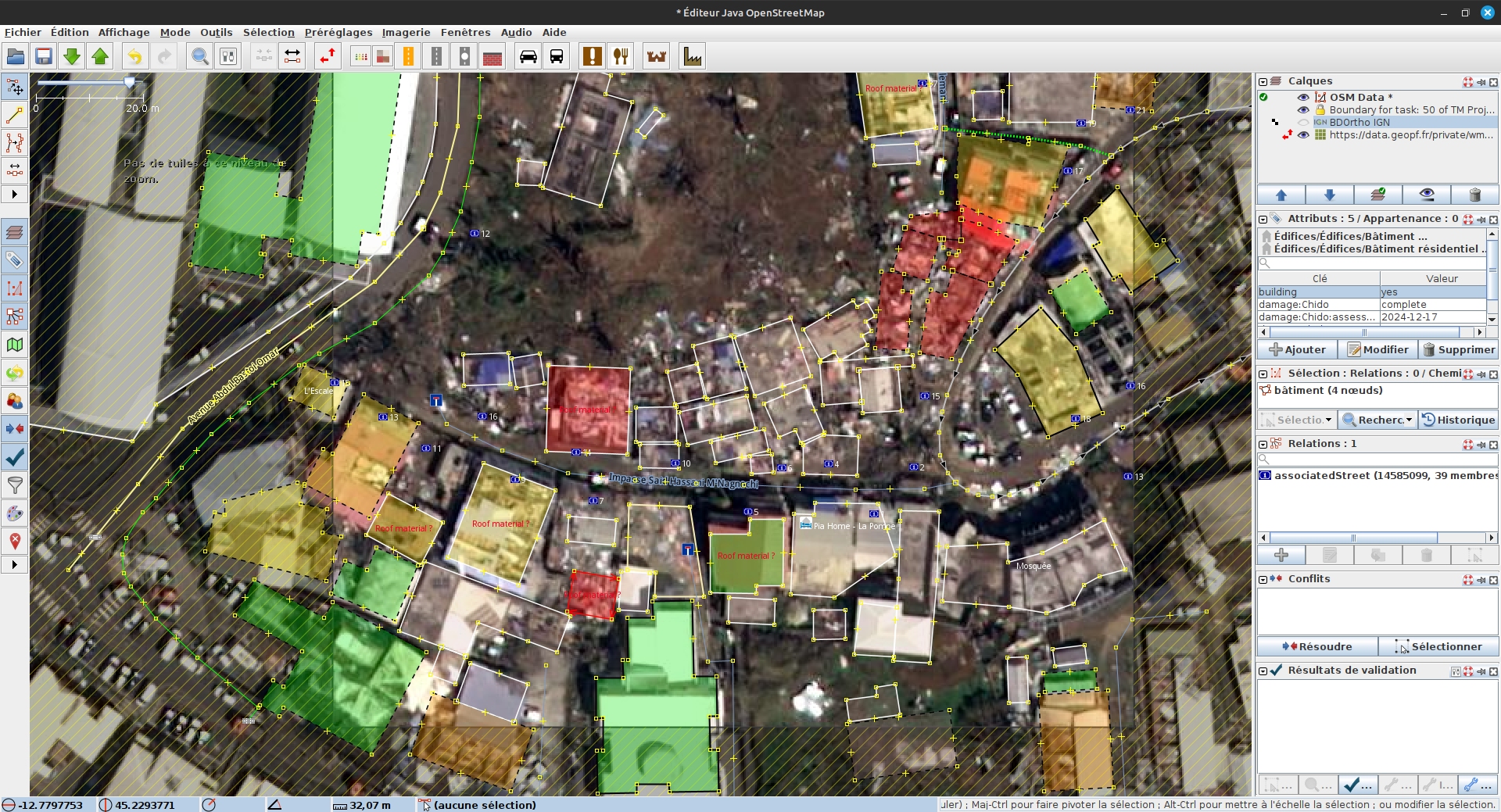
 Travaux d'évaluation des dégâts sur #Mayotte sur #OpenStreetMap via #HOTOSM. État de destruction de chaque bâtiment évalué (
 aucun,
  minimal,
  important,
  complet). Outil : #JOSM. Photos post-cyclone fournies pas le #CNES #Airbus.
  URL projet : https://tasks.hotosm.org/projects/18320/tasks/
 @openstreetmap@en.osm.town @osm_fr @openstreetmap@lemmy.ml
 #humanitarian #humanitaire #OSM #climate #climat #solidarité #logicielslibres #opensource #freesoftware #FOSS #FLOSS #cartographie #cartography #hurricane #HOTOSM


@Yivan000 If I’m not mistaken, OSM Inspector updates on a daily basis (basically aligned with the daily OSM dumps of @geofabrik). If #JOSM says there are no gaps, then the route should work.
If you want, you can share links to your changeset(s) so others here can check it out.
@OpenStreetMapUS Are AI animals allowed #josm :)
@joeldn, yup, I am well aware of @edward’s tool because we both co-presented about linking OSM with Wikidata (including demoing his tool) twice: once at State of the Map 2019...
... and the other at WikidataCon 2019:
https://commons.wikimedia.org/wiki/File:OpenStreetMap_and_Wikidata_(WikidataCon_2019).pdf
Edward’s tool only adds wikidata=* tags and I usually do other edits and clean-ups so I still use #JOSM for editing. 


I've had it up to here with #josm using garbage AI furry image stuff for their homescreen. (this is coming from a furry myself btw)
For context: #JOSM (a very popular #OpenStreetMap editor) has in recent weeks been using ai images (seems like there's a new one every day) to raise awareness for their translation project. They want more translations to happen for the JOSM application.
https://community.openstreetmap.org/t/ai-ferrets-take-over-josm/125426/6 

Really disappointing #JOSM is continuing to use #AISlop in the MOTD. #OpenStreetMap

FFS, one day of Bing in #JOSM is all we get, really? Can we focus on that rather than new images of animals every day? I just want to map!
#openstreetmap

Couple years ago I got sad every time I saw a good person I know fall for crypto and NFT. Now I get sad seeing good developers falling for AI.
I understand it is hard to resist huge corporations shoving it in your face, but we have more brains and love for people than corporations, we can know better.
(this is about #JOSM, yes.)

Anyone else having issues with #bing imagery in #josm? I keep getting an error (attribution something, I can’t recall it now) and the imagery doesn’t load. #OpenStreetMap

#JOSM devs are currently looking for people who can help with translations.
But if you are not interested, seeing those images on the home screen is an annoyance.
Here is how you can blank the entire page.
Edit > Preferences > Advanced Preferences
Set help.displaymotd to false.

 re
re The latest version of #JOSM, the Java #OpenStreetMap editor shows this announcement , with an illlustration of a tiger pointing to the viewer, and the text "JOSM Needs You for the 2025 translation initiative.
Details are available here: JOSM I18n contest 2025

#JOSM had several furries sitting around a map discussing it in the MOTD yesterday, one furry's a coincidence, two furries in a row is certainly a pattern, and a welcome one.
Not sure "i18n" is particularly parseable to people who need it, in similar how "a11y" isn't particularly accessible to the illiterate and really wonder if we can drop both in favor of just spelling it?
