toad.social is one of the many independent Mastodon servers you can use to participate in the fediverse.
Mastodon server operated by David Troy, a tech pioneer and investigative journalist addressing threats to democracy. Thoughtful participation and discussion welcome.

Administered by:

Server stats:

211
active users

#hikingview

0 posts0 participants0 posts today
Mid July two years ago we've been on a weekend trip by train to Garmisch-Partenkirchen and were going to sleep in a mountain hut for the first time.
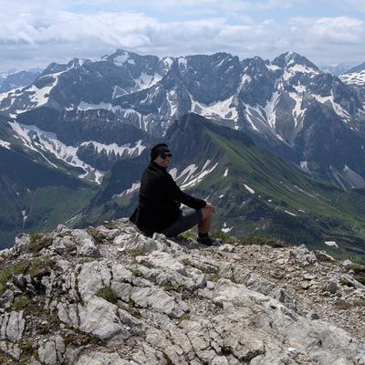
After a very bright and hot saturday on our way up to the Kreuzeckhaus, most of sunday was rather soupy and cold. The sun only came out once we were nearly back in town.

#TBT #ThrowbackThursday #Throwback #GarmischPartenkirchen #Garmisch #Partenkirchen #Bayern #Bavaria #Zugspitzbahn #Alpen #Alps #Berge #Mountains #Kreuzeckhaus #Hiking #Hike #Hikes #Hiker #HikingTrail #GoHiking #HikingView #HikingAdventures #Wanderlust #Wandern #MountainHut #Summer #Sommer #BahnZumBerg #BzB #Travel #PublicTransit #PublicTransport #ScenicsNature #Nature #OutdoorAdventure
Lots of rain and thunderstorm on Thursday last week, so I delayed my departure from the Zillertal to have enough time for another adventure on Friday.

I got up early, took the train to Mayrhofen at 06:52 and transferred onto a bus via mountaineering village Ginzling to the Schlegeisspeicher where I started my hike at 08:30.

After roughly 70 walking minutes I reached the Olperer hut at 2388 metres above the Adriatic.
Afterwards my round trip, the Neumarkter Runde, continued over a ridge into a spacious cirque and back down again. Because there were far less people on this route than usual, it really was a an amazing atmosphere.

Before the bus back to Mayrhofen departed, I enjoyed a fast - but nevertheless delicious - meal at the Dominikushütte, where I also had a pleasant chat with the inn keeper.

Duration: 3 hours and 10 minutes (excluding various breaks accumulating to 1 hour and 20 minutes)
Length: 10 km
Elevation: 1785 m to 2435 m
Ascent/Descent: 675 m ↑ and 675 m ↓

#Hiking #Hike #Hikes #Hiker #HikingTrail #GoHiking #HikingView #HikingAdventures #Wanderlust #Wandern #Schlegeisspeicher #Olpererhütte #Dominikushütte #NeumarkterRunde #Brücke #Bridge #Zillertal #Zillertalbahn #Tyrol #Tirol #Austria #Österreich #Alpen #Alps #Berge #Mountains #GlacierViews #MountainLake #Bergsee #Stausee #Reservoir #MountainHuts #MajesticMountains #MountainEscape #Summer #Sommer #BahnZumBerg #BzB #Travel #PublicTransit #PublicTransport #Trains #Züge #ScenicsNature #Nature #OutdoorAdventure
On Wednesday we used the hiking taxi from Mayrhofen to the Stilluptal and had a relaxing stroll through the valley.

Duration: 2 hours and 30 minutes (excluding various breaks accumulating to 40 minutes to enjoy the peaceful valley)
Length: 9.25 km
Elevation: 1120 m to 1495 m
Ascent/Descent: 85 m ↑ and 400 m ↓

#Hiking #Hike #Hikes #Hiker #HikingTrail #GoHiking #HikingView #HikingAdventures #Wanderlust #Wandern #Stillup #Stilluptal #Zillertal #Tyrol #Tirol #Austria #Österreich #Alpen #Alps #Berge #Mountains #MountainLake #Bergsee #Waterfall #Wasserfall #Summer #Sommer #Travel #ScenicsNature #Nature #OutdoorAdventure
To escape the heat down in the valley I embarked on a short hike yesterday: from Speichersee Hochzillertal to Gedrechter peak at 2217 and Arbiskopf peak at 1920 meters above sea level and back down again to Murmelland Zillertal.

Duration: 2 hours (excluding a 40 minute break at the peak to enjoy the panorama)
Length: 6.5 km
Elevation: 1780 m to 2217 m
Ascent/Descent: 490 m ↑ and 500 m ↓

#Hiking #Hike #Hikes #Hiker #HikingTrail #GoHiking #HikingView #HikingAdventures #Wanderlust #Wandern #Ziller #Zillertal #Tyrol #Tirol #Austria #Österreich #Alpen #Alps #Berge #Mountains #MountainLake #Bergsee #Gipfel #Gipfelkreuz #Peak #Gedrechter #Arbiskopf #Murmeltier #Murmelland #Marmot #Summer #Sommer #Travel #ScenicsNature #Nature #OutdoorAdventure
Right now I am in vacation in Zillertal for a few days.
Yesterday I started with some longer sprinting sessions as part of my training plan early in the morning and breakfast afterwards. The remaining morning was used for an easy hike from Ramsau im Zillertal to Zell am Ziller via Talbachwasserfall.

Duration: 2 hours and 15 minutes (excluding two 5 minute breaks)
Length: 7.5 km
Elevation: 580 m to 750 m
Ascent/Descent: 300 m ↑ and 300 m ↓

#Hiking #Hike #Hikes #Hiker #HikingTrail #GoHiking #HikingView #HikingAdventures #Wanderlust #Wandern #Ziller #Zillertal #Tyrol #Tirol #Austria #Österreich #Alpen #Alps #Berge #Mountains #Wasserfall #Waterfall #Summer #Sommer #Travel #ScenicsNature #Nature #OutdoorAdventure
During the first days of May I've been on a 4-day-trip to Luxembourg with a dear friend of mine.

After arriving in Luxembourg City and checking in our hotel on Wednesday evening, we got up early and tested the free public transit on Thursday.
With an intercity train, a funicular and by bus we travelled to Echternach which lies near the border with Germany and is the oldest town in Luxembourg.
We had a clear and - atleast for us - ambitious goal in mind: stage two of the popular Mullerthal trail.

Duration: 9 hours and 5 minutes (excluding various breaks accumulating to more or less 2 hours)
Length: 37.75 km
Elevation: 160 m to 385 m
Ascent/Descent: 950 m ↑ and 950 m ↓

#Hiking #GoHiking #HikingView #HikingAdventures #HikingLuxembourg #Wanderlust #Wandern #Luxembourg #Luxemburg #Letzebuerg #VisitLuxembourg #Müllertal #Mullerthal #Mëllerdall #MullerthalTrailMoments #MullerthalRegion #MüllertalTrail #MullerthalTrail #Trail #TrailMemories #LittleSwitzerland #KleineLuxemburgerSchweiz #Echternach #Sandsteinfelsen #Sandstone #Sun #Sunlight #Forest #ForestLovers #Waldbaden #Travel #ScenicsNature #Nature #OutdoorAdventure